
offer
georadar
about us
geophisical service
geotechnics and geology
hydrogeology
environment
examples
links
contact
Georadar - Ground Penetrating Radar (GPR) - profiling and 2D/3D mapping
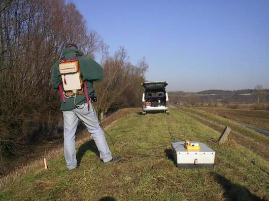
 Ground Penetrating Radar (GPR) is a high resolution, field-portable geophysical method that produces graphic sections of subsurface
structure. A typical GPR system consists of an antenna unit, signal control console, display monitor and graphic recorder.
The antenna unit is in direct ground contact with the remaining equipment vehicle-mounted. Data is collected along accurately
located survey profiles.
Ground Penetrating Radar (GPR) is a high resolution, field-portable geophysical method that produces graphic sections of subsurface
structure. A typical GPR system consists of an antenna unit, signal control console, display monitor and graphic recorder.
The antenna unit is in direct ground contact with the remaining equipment vehicle-mounted. Data is collected along accurately
located survey profiles.
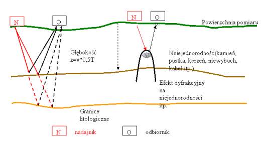
 Electromagnetic impulses of UHF/VHF frequency are emitted from the moving antenna and propagated into the ground.
Impulses are reflected at subsurface boundaries where an electrical contrast is present. Reflected signals are detected
by the antenna receiver and digitally stored for post-survey data processing and interpretation.
Electromagnetic impulses of UHF/VHF frequency are emitted from the moving antenna and propagated into the ground.
Impulses are reflected at subsurface boundaries where an electrical contrast is present. Reflected signals are detected
by the antenna receiver and digitally stored for post-survey data processing and interpretation.
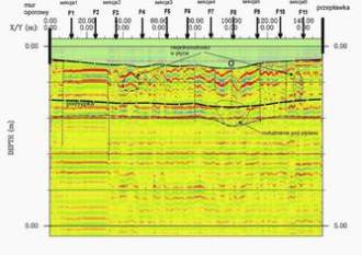
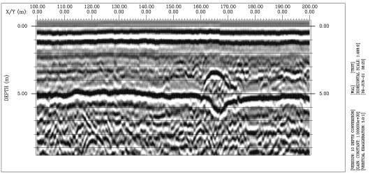 Post-survey digital processing of the data using specialized interactive software optimizes survey results.
Data interpretation procedures correlate reflections on the radar record with real physical interfaces in the ground such as
soil or rock layering, voids, foundations and archaeological structures.
Post-survey digital processing of the data using specialized interactive software optimizes survey results.
Data interpretation procedures correlate reflections on the radar record with real physical interfaces in the ground such as
soil or rock layering, voids, foundations and archaeological structures.
Variable frequency, interchangeable antenna units are used with the GPR system, depending on the application. Low frequency units offer greater depth penetration and are generally better suited for civil engineering and geological site investigations. Small portable, high frequency units are used for high resolution work involving NDT of concrete or masonry.
GPR method is non-destructive, revealing subsurface detail without requiring coring, breaking out or other types of destructive testing.
Small portable, high frequency units are used for high resolution work involving NDT of concrete or masonry.
GPR method is non-destructive, revealing subsurface detail without requiring coring, breaking out or other types of destructive testing.
Applications: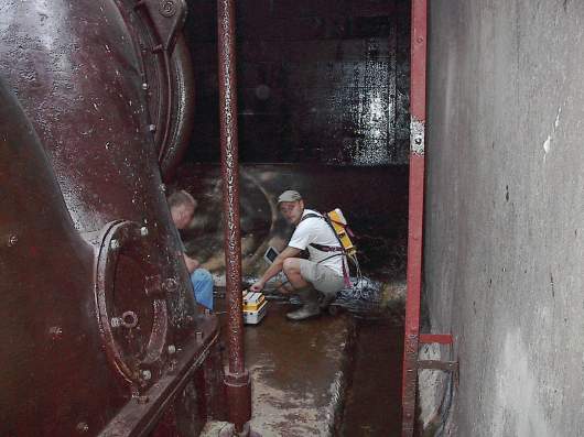
Variable frequency, interchangeable antenna units are used with the GPR system, depending on the application. Low frequency units offer greater depth penetration and are generally better suited for civil engineering and geological site investigations.
Applications:
- Locates buried voids & cavities,
- Determines depth of bedrock and overburden thickness,
- Finds buried underground storage tanks and drums,
- Tracks non-metallic culverts and sewers,
- Maps buried foundations and other obstructions,
- Defines extent of ancient landfills,
- Investigates thickness and internal structure of floors and walls,
- Locates internal steelwork in concrete such as rebars, girders & cable ducts,
- Identifies ties between courses of brickwork,
- Locates voids, cracks and delaminations in all types of materials,
- Finds zones of water penetration and corrosion within defective concrete,
- Determines thickness of brickwork and masonry construction layers.