
offer
georadar
about us
geophisical service
geotechnics and geology
hydrogeology
environment
examples
links
contact
Geopartner provides specialist investigation services for geophysical and specialist structural investigations mainly
connected with subsurface layers of lithosphere. We have great experience in investigation works as well as geophysical
data processing and interpreting. Both site works and desk studies are carried on and supervised by specialist geophysicists
and geologists under dr Kazimierz Bylica who has got over twenty years experience. This fact ensures that methodologies and
acquisition processes are adapted to provide the optimum results for the particular investigation. Naturally all stages of
an investigation are carried out under a certified quality management system. This system is designed not only to provide
traceability of data and activities but also tracks the analysis processes to ensure the confidence of our clients.
Geopartner is proud of tens of realized commissions during which there were made and interpreted over 400 km of GPR,
electromagnetic and seismic profiles.
Geophysics involves the measurement of physical properties, usually from the Earth surface, to obtain useful information on the structure and composition of the concealed subsurface through comprehensive interpretation of the measured data. Geopartner possesses modern equipment, software and specialist staff what allows to make measurements in the folowing kinds of investigations:
1. EM - Electromagnetic /induced ground conduction/ profiling and 2D mapping
Electromagnetic (EM) systems measure ground conductivity by electromagnetic induction.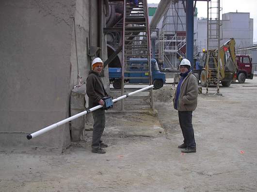 The systems consist of transmitter and receiver coils set at standard configurations. The transmitting coil outputs a primary
electromagnetic field which induces a secondary field in the ground. The receiving coil measures the magnitude of the secondary
field (quadrature component) and the ratio between the primary and secondary fields (in-phase component). Quadrature fields
are proportional to ground conductivity, which is sensitive to bulk changes in lithology, groundwater or ground contamination.
Metal produces strong secondary fields making the in-phase component useful for finding buried metal targets.
The systems consist of transmitter and receiver coils set at standard configurations. The transmitting coil outputs a primary
electromagnetic field which induces a secondary field in the ground. The receiving coil measures the magnitude of the secondary
field (quadrature component) and the ratio between the primary and secondary fields (in-phase component). Quadrature fields
are proportional to ground conductivity, which is sensitive to bulk changes in lithology, groundwater or ground contamination.
Metal produces strong secondary fields making the in-phase component useful for finding buried metal targets.
During survey operations the equipment is suspended above the ground, rather than in direct contact with the ground. This makes EM surveys very rapid and cost effective in comparison to conventional resistivity surveys. Data is collected as point readings taken at regular intervals along a grid of survey lines over the site area. The spacing between grid-lines and reading stations will depend on the size of the targets under investigation, with smaller targets generally requiring more densely spaced readings. Data readings are recorded by a digital data logger and downloaded to a PC for post-survey processing and interpretation.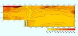 The most commonly used interpreation procedure is contouring which identifies anomalous features relative to background
levels using specialist interactive software. Survey results are presented as plans in an engineering compatible format
that is readily understandable by the client.
The most commonly used interpreation procedure is contouring which identifies anomalous features relative to background
levels using specialist interactive software. Survey results are presented as plans in an engineering compatible format
that is readily understandable by the client.
Applications:
2. SEISMIC REFRACTION - profiling and 2d/3D mapping
Seismic refraction is a geophysical method used for investigating subsurface ground conditions utilising surface-sourced seismic waves. The acquired data is computer processed and interpreted to produce models of the seismic velocity and layer thickness of the subsurface ground structure.
Pulses of low frequency seismic energy are emitted by a seismic source such as a hammer-plate, weight drop or buffalo gun. The type of source is dependant on local ground conditions and required depth penetration. Explosives are best for deeper applications but are constrained by evironmental regulations.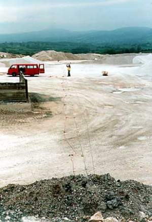 The seismic waves propagate downward through the ground until they are reflected or refracted off subsurface layers.
Refracted waves are detected by arrays of 24 or 48 geophones spaced at regular intervals of 1 - 10 meters, depending
on the desired depth penetration of the survey. Sources are positioned at each end of the geophone array to produce
forward and reverse wave arrivals along the array. Additional sources may be used at intermediate or off-line positions
for full coverage at all geophone.
The seismic waves propagate downward through the ground until they are reflected or refracted off subsurface layers.
Refracted waves are detected by arrays of 24 or 48 geophones spaced at regular intervals of 1 - 10 meters, depending
on the desired depth penetration of the survey. Sources are positioned at each end of the geophone array to produce
forward and reverse wave arrivals along the array. Additional sources may be used at intermediate or off-line positions
for full coverage at all geophone.
Geophones output data as time traces which are compiled and processed by the seismograph. The basic components of a seismic trace are the direct wave, the reflected wave and the critically refracted wave. Wave refraction occurs at interfaces in the ground where the seismic velocity of the lower layer is greater than the velocity of the overlying layer. This condition normally applies in near surface site investigations where soil or fill overlies bedrock.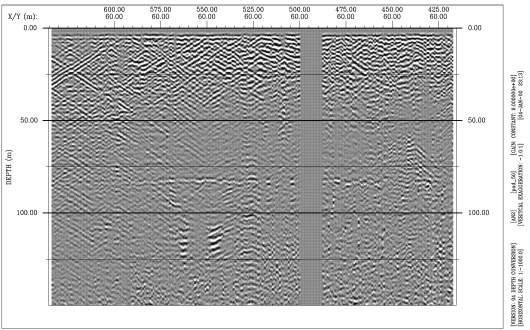 Applications:
Summing up
The present geophysical te hniques are very important and sometimes the only device of solving many problems concerning geology, geotechnics, widely understood engineering and environment protection .Great development of geophysical techniques in recent years adopted geophysical methods to many applications. They are able to give extensive coverage of a site for relatively small cost, enabling details of ground structure to be established prior to the use of conventional borehole drilling.
Geophysics in geology and geotechnics
Geophysics involves the measurement of physical properties, usually from the Earth surface, to obtain useful information on the structure and composition of the concealed subsurface through comprehensive interpretation of the measured data. Geopartner possesses modern equipment, software and specialist staff what allows to make measurements in the folowing kinds of investigations:
1. EM - Electromagnetic /induced ground conduction/ profiling and 2D mapping
Electromagnetic (EM) systems measure ground conductivity by electromagnetic induction.
During survey operations the equipment is suspended above the ground, rather than in direct contact with the ground. This makes EM surveys very rapid and cost effective in comparison to conventional resistivity surveys. Data is collected as point readings taken at regular intervals along a grid of survey lines over the site area. The spacing between grid-lines and reading stations will depend on the size of the targets under investigation, with smaller targets generally requiring more densely spaced readings. Data readings are recorded by a digital data logger and downloaded to a PC for post-survey processing and interpretation.
Applications:
- Finds voids & solution features in soil and rock
- Locates former mineshafts, crown holes & subsidence features
- Detects bedrock discontinuities & mineralised veining
- Identifies former landfill site & associated leachate plumes
- Locates buried UST's and chemical waste drums
- Detects saline groundwater incursions & heavy metal concentrations
2. SEISMIC REFRACTION - profiling and 2d/3D mapping
Seismic refraction is a geophysical method used for investigating subsurface ground conditions utilising surface-sourced seismic waves. The acquired data is computer processed and interpreted to produce models of the seismic velocity and layer thickness of the subsurface ground structure.
Pulses of low frequency seismic energy are emitted by a seismic source such as a hammer-plate, weight drop or buffalo gun. The type of source is dependant on local ground conditions and required depth penetration. Explosives are best for deeper applications but are constrained by evironmental regulations.
Geophones output data as time traces which are compiled and processed by the seismograph. The basic components of a seismic trace are the direct wave, the reflected wave and the critically refracted wave. Wave refraction occurs at interfaces in the ground where the seismic velocity of the lower layer is greater than the velocity of the overlying layer. This condition normally applies in near surface site investigations where soil or fill overlies bedrock.
- Measures Bedrock Depth & Overburden Thickness
- Determines Rippability Parameters
- Investigates Pipeline Routes
- Locates Geological Structures
- Evaluates Sand & Gravel Deposits
- Defines Ancient Landfill Sites
Summing up
The present geophysical te hniques are very important and sometimes the only device of solving many problems concerning geology, geotechnics, widely understood engineering and environment protection .Great development of geophysical techniques in recent years adopted geophysical methods to many applications. They are able to give extensive coverage of a site for relatively small cost, enabling details of ground structure to be established prior to the use of conventional borehole drilling.
Geophysics in geology and geotechnics
- thickness of layers
- depth of bedrock
- horizontal and vertical lithology layout
- stratygraphy
- geological structures /folds, faults, karst/
- ancient river channels
- water table and water bearable layers
- range of mineral deposits and useful mineral
- mineralization of ground and water
- cleavage
- cracking of concrete and its reinforcement
- locating underground infrastructure / pipelines, cables, cables, foundations/
- hidden cellars, secret passages
- tightness of tanks, tight walls etc.
- thicknes of settlements
- geometry of waists dumps
- underground pipelines and tanks leaching
- contouring contamination zones
- locating of landfils
- searching for explosives
- locating buried corridors, walls, tombs
- Finding ancient fire hearths & metal ornaments, ceramics
- Present recognition of excavations
- Lake and river bottom profiling
- Assessing defects in barrages, locks, dams and weirs
- Water power stations inspections
- Testing the structure of dikes
- Testing coast stability
- deposits size profiling
- deposit extensity determining
- searching for ancient river channels
- locating non extensive structures, e.g. veins, diapirs, etc.
-
Discovering mines and explosives
Locating contaminated areas
Inventory of secret infrastructure